Version HTML de base


5
9
13
12
9
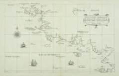
DUDLEY, R.
Carta Particolare della Brittania Bassa in
Francia Florence, 1661. Restaurations et consolidations
en bas du pli central. Encadrée. 470 x 750 mm. 750/850
S
econde édition. L’atlas de Dudley «Arcano del Mare», est le
premier atlas maritime anglais couvrant le monde. Les cartes
sont gravées par Lucini.
Robert Dudley (1574-1649). English geographer. His rare
atlas ‘Arcano del Mare’ was the first English sea-atlas, the first
with charts - all in Mercator-projection- of the whole world.
Famous for its engraving by Lucini. 1st. Ed. 1646-7, 2nd. Ed.1661.
Engraved by Lucini. Sir Robert Dudley’s Dell’Arcano del Mare is
the earliest printed sea atlas to cover the entire world, and the
first made by an Englishman, and the first to use the Mercator
projection. It collects all the naval knowledge of its time. It was
first published in Italian at Florence in 1645, then again in 1646 in
a three volume folio, and which is remarkable for its inclusion
of a proposal for the construction of a navy in five rates which
Dudley designed and described. It was reprinted in Florence in a
two volume folio in 1661 without the charts of the first edition.
The distinctive Baroque style of Dudley’s charts, is attributable
to the elegant engraving of Antonio Francesco Lucini.
The six-volume work covered navigation, shipbuilding and
astronomy, with 130 maps in two volumes. Unlike the vast
majority of his contemporaries, Dudley’s maps are all his own
and were not copied from other mapmakers. They have an
instantly recognizable style, closer to the pre-17th-century
manuscript portolan charts than the richly decorated maps
of Mercator, Hondius and Blaeu. Later map-makers chose not
to copy Dudley’s style and so it remains unique in the annals
of cartography. The engraving by Antonio Francesco Lucini,
who stated that he spent 12 years and used 5,000 pounds of
copper to produce the plates, is of exceptional quality, as is
the calligraphy.
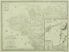
10
MONTECALERIO, J.
Provincia Britanniae armoricae.
Milan, 1712. Pâles rousseurs marginales. Encadrée.
225 x 320 mm.
100/150
In « Atlas des Capucins ». Deuxième état.- Gaudillat N° 35.
11
ANONYME.
A Chart of the Bay of Biscay from the Isle
Ouessant to Cape Finisterre. Ca. 1793. Infimes petites
taches brunes. Encadrée. 450 x 575 mm.
100/120
Comprend en carton une carte de la Baie de Quiberon
(Guerre de Vendée) intitulée : « Carte d’une partie des côtes
de France et de la Baie de Quiberon. Pour l’intelligence de
la campagne faite en cette partie depuis le 27 juin jusqu’au
27 juillet 1792 ».
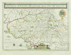
12
BLAEU, G.
Pictaviae Ducatus Descriptio Vulgo le Pais
de Poictou. Amsterdam, 1655. Beau col. d’époque. Bel
exemplaire. Encadrée. 380 x 520 mm.
100/150
Carte du Poitou représentant la côte avec les îles de Ré et
d’Oléron. Elle est ornée d’armoiries et d’un cartouche d’échelle,
le titre est inscrit dans une bannière au-dessus de la carte.
13
LAPIE.
Carte du théâtre de la guerre de Vendée et des
Chouans. Paris, 1806. Traces de pliures verticales et
horizontales, pâle rousseur en haut à gauche de la carte.
Encadrée. 400 x 543 mm.
100/120
Carte de la guerre de Vendée publiée en 1806 dans l’ouvrage
d’Alfonse Beauchamp : Histoire de la Guerre de VENDÉE et des
CHOUANS, depuis son origine jusqu’à la pacification de 1800.