Version HTML de base


notices géographiques. L’atlas est illustré de 11 cartes pour
l’Amérique (Nord et Sud), 3 pour l’Océanie (1 pour l’Australie),
2 pour la Suisse, 12 pour l’Asie et 8 pour l’Afrique.
AFRIQUE
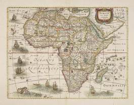
20 HONDIUS, H. / JANSSONIUS, J. Africae nova Tabula.
Amsterdam, 1631 [1639-1649]. Beau col. d’époque.
Bel exemplaire. - A very good copy. In original colours.
375 x 492 mm.
700 / 900
€
Troisième état de cette carte d’Afrique très décorative, ornée de
7 bateaux, de monstres marins et de sirènes. - A third state of
this fine map of Africa first issued by Jodocus Hondius. There
are six ships in full sail on the Atlantic and one to the south of
Madagascar. Flying fish and various monsters decorate the sea.
Neptune and a mermaid are riding the waves lower left. French
text on verso. - Betz, Africa, 58.3.
21 JAILLOT, H. / MORTIER, P. L’Afrique divisee suivant
l’estendue de ses principales parties. Amsterdam,
Pierre Mortier, s.d. [ca. 1705]. Limites en col. d’époque.
Carte en 2 feuilles jointes. Fente sur 4 cm dans la
marge gauche, pâles rousseurs. 545 x 870 mm.
700 / 900
€
Edition hollandaise publiée à Amsterdam, chez Pierre Mortier.
Grand cartouche de titre décoratif. - From Mortier’s issue of
Jaillot’s “Atlas Nouveau”. - Pastoureau, Jaillot I F.
22 HOMANN, J.B. Totius Africae nova repraesentatio.
Nuremberg, 1720. Beau col. d’époque. Pli central res-
tauré légèrement disjoint dans sa partie inférieure avec
traces de colle. - Some very light browning. Repair lower
part center fold, split not well closed. 485 x 566 mm.
650 / 750
€
Belle carte d’Afrique et de la Péninsule Arabique. Le tracé du Nil
est basée, en partie, sur Ptolémée et en partie, sur la décou-
verte de la source du Nil au XVIe siècle par le Portuguais Paez.
- Richly ornamented map of Africa and the Arabian Peninsula.
With an extraordinary delineation of the Nile which is based
partly on Ptolemy (rising in two large lakes, Zaire and Zaflan)
and partly on the 16th century discovery of the source of the
Nile by the Portuguese Paez. This however is placed far to the
south below Lake Zaire, a part of Abyssinia in 20 degrees
south. - Tooley, Maps of the African continent, p. 51.
23 JANSSON, J. Nova Barbariae Descriptio. Amsterdam,
1639-1649. Beau col. d’époque. Pâle mouillure dans la
marge supérieure. 357 x 502 mm.
150 / 200
€
Carte représentant l’Afrique du Nord du Maroc à l’Egypte.
Ornée de 2 cartouches et de nombreux animaux exotiques :
éléphants, singes, autruches, lions, crocodiles …
24 JANSSON, J. Fezzae et Marocchi Regna Africae cele-
berrima. Amsterdam, 1639-1649. Beau col. d’époque.
Infimes rousseurs, papier légèrement jauni. Mouillures
marginales. Petite restauration en bas du pli central.
387 x 502 mm.
200 / 300
€
Texte en français au verso. - An attractive map of northwest
Africa and Morocco. The Pillars of Hercules & Straits of
Gibraltar, and Spain are shown to the right of the map (north is
to the right of the map). Blaeu credits Ortelius and his 1570 map
as the source of data for this map. Spain controlled portions of
this area from 1580 until 1640 along the coast at Ceuta,
Tangier, and Arzilla. A sea battle is shown in the Atlantic ocean.
- Small repair in lower part center fold.
25 JANSSON, J. Aethiopia Inferior vel Exterior.
Amsterdam, 1639-1649. Beau col. d’époque. Pâles
mouillures dans les marges. 381 x 500 mm.
200 / 300
€
La carte couvre un territoire qui s’étend du Congo-Zanzibar
jusqu’à l’Afrique du Sud. - The standard map of South Africa
throughout the 17th century. The map covers an area from
Congo-Zanzibar to the Cape. It was published before Van
Riebeeck settled at the Cape, and such knowledge of South
Africa as cartographers had was based on prior Portuguese
exploration, traveler’s table and rumors about the interior… - In
attractive original colours. - Koeman/Krogt, Atlantes
Neerlandici, 8800:1.
26 JANSSON, J. Aethiopia superior vel interior.
Amsterdam, 1639-1649. Beau col. d’époque.
Mouillures dans les marges. 384 x 495 mm.
200 / 300
€
An attractive map of the Eastern African and the fictitious king-
dom of Prester John. The map shows a major section of cen-
tral and eastern Africa including Mozambique north to present
8
20