Version HTML de base


15
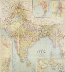
Deux grands plans de Calcutta publiés sous la direction du
Colonel C. P. Gunter, O.B.E., R.E., Officiating Surveyor General
of India. - Published under the direction of Colonel C. P. Gunter,
O.B.E., R.E., Officiating Surveyor General of India. National
government publication. Inset : Index to districts, municipalities,
& municipal wards.
51 HONDIUS, J. / JANSSON, J. Ins. Ceilan que incolis
Tenarisin dictur. Amsterdam, 1639-1649. Beau col.
d’époque. Bel exemplaire. - In good condition. With
wide margins. In original colours. 342 x 497 mm.
200 / 300
€
Très belle carte figurant Ceylan par Petrus Plancius, orientée
vers l’est. Texte en français au verso. - In 1606 Jodocus
Hondius introduced in the Mercator Atlas a separate map of
Ceylon. Prepared by Petrus Plancius. Oriented to the east.
52 PERTHES, J. Hinterindien. Gotha, J. Perthes, 1832.
Limites en col. d’époque. Carte en 21 segments entoi-
lée et repliée. Bel exemplaire. 885 x 590 mm.
200 / 300
€
Carte figurant une partie de la Chine et l’Asie du Sud-Est, gra-
vée par W. Brose à Berlin.
53 JANSSON, J. Indiae Orientalis Nova Descriptio.
Amsterdam, 1639-1649. Beau col. ancien. Pâles mouil-
lures dans les marges. - In original colours. Paper
slightly age-toned as usual, water stains in left and top
margins. 390 x 540 mm.
600 / 700
€
Carte de l’Asie du Sud-Est comprenant la péninsule indochi-
noise. - Fine decorative chart of the region including Indochina,
the Philippines and the East Indies. Includes the new discove-
ries in New Guinea made by the Dutch “Duyfkens” exploration.
French text on verso.
CHINE - JAPON
54 JANSSON, J. Tartaria sive magni chami imperium.
Amsterdam, 1639-1649. Beau col. ancien. Papier légè-
rement bruni. - Paper slightly age-toned as usual. 382
x 497 mm.
200 / 300
€
Detailed and decorative map of Tartary and Northern part of
China. Northern tip of Korea included. The Chinese Great Wall
is depicted.
55 ORTELIUS, A. Iaponiae Insulae Descriptio. Ludoico
Teisera auctore. Anvers, ca. 1595. Col. d’époque.
Encadré. Papier légèrement plus clair le long du pli
central. - In original colours. Some very light marginal
discolouration along center fold. Framed. 355 x
485 mm.
1 000 / 1 200
€
Très belle carte du Japon et de la Corée d’après le modèle
manuscrit de Luis Teixeira, célèbre cartographe de marine por-
tuguais et cartographe de la cour d’Espagne. - The map was
based upon the manuscript draft supplied to Ortelius in about
1592 by the famous official Portuguese chart maker, Luis
Teixeira, who was the cartographer to the court of the Spanish
King. Korea is shown as an elongated island whilst Japan is
shown with just the three principal islands of the archipelago. -
OAG, Walter, 19; Van den Broecke, Ortelius maps, 165.
TAHITI
56 ANONYME. Taïti. Rade de Papeete le 28 7.bre 1853 /
Rade de Papeete 29 7.bre 1853 / Papeete 27 Août
1853 / Tanoa Le 25 Novembre 53. Le Diadème. Tahiti,
1853. Quatre dessins à la mine de plomb sur papier
fort, extraits d’un carnet de dessins. Papier fortement
jauni. 135 x 225 mm.
500 / 800
€
Quatre dessins figurant la rade de Papeete et le Diadème (Te
Hena o Mai’ao) réalisés par un voyageur en 1853 et extraits
d’un carnet de dessins.
48