Version HTML de base


3
B
CARTES GÉOGRAPHIQUES ANCIENNES
C
A.
SCHENK, P.
Carte qui représente toutes les pièces qui sont comprises dans l’architecture militaire…/ Tafel… Tot de Krygskunde….
Amsterdam, 1703. Col. 480 x 600 mm. Coloris postérieur. Collé en plein, traces de pliures verticales, petites restaurations le long du
pli central et en bas de planche, petit manque de papier au milieu du pli central, pâles rousseurs. Encadré.
200/300
Planche d’architecture militaire figurant les systèmes de fortification ainsi que les armes et techniques d’attaque et de défense. Légendée en français
au-dessus de la carte, en néerlandais pour le cartouche et les explications numérotées de 1 à 84 sous la planche.
- An attractive instructional plate showing a collage of various systems of fortifications, both inland and coastal, and the weapons and techniques
used to attack and defend them. At the foot are engravings of cannon and their munitions. A fascinating plate for the greater understanding of military
equipment and practices at a time of great international military activity. With extensive key.
B.
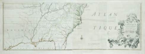
MITCHELL, J. / LE ROUGE.
Amerique Septentrionale avec les Routes, Distances.. Paris, 1777. Limites col. 715 x 1910 mm. Carte en
4 feuilles jointes (sur 8). Papier froissé dans la partie centrale, pâles rousseurs, large déchirure restaurée dans la carte en haut à droite
et 2 déchirures restaurées dans la partie supérieure. Encadré. - 4 sheets joined (of 8). Crease marks in the center, one large tear in the
right upper part and two tears in the upper part repaired. Slight foxing. Framed, not inspected out of the frame.
2 000/2 500
Partie inférieure seule (en 4 feuilles jointes) de la carte murale copiée sur celle de Mitchell publiée en 1755. Elle figure les concessions britanniques
de Virginie, Caroline et Géorgie s’étendant au-delà du Mississipi jusqu’à l’Océan Pacifique. C’est la carte la plus importante pour l’histoire américaine.
- The lower half (in 4 sheets) of the wall map copied after the famous one by Mitchell of 1755, presenting the British Colonial claims of
Virginia, both Carolinas, and Georgia extending beyond the Mississippi to the Pacific Ocean. From from Le Rouge’s “Atlas Américain Septentrional”
(1778) with several French notes, but also one in
German at upper right corner. The most important
map in American history. - Mitchell, a doctor and
botanist of some repute, published his map in 1755
in order to stimulate interest among the British
authorities regarding the protection and expansion
of British interests in North America. Mitchell’s map
was presented in the House of Commons during
the debates regarding the Quebec Art of 1774. It
was the only comprehensive map of the theatre
of war during the American Revolution and the
authoritative cartographical document referred to
during the negotiations of peace in Paris in 1782 and
1783. It was used many times in history up until 1927
during the Canada-Labrador boundary case and as
late as 1932 in the New Jersey-Delaware boundary
case. - Cf.Kershaw 349 with plate 230.
C.
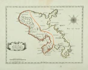
MARIETTE, P.
L’Isle de la Martinique. Paris,
Mariette, ca. 1670. Limites en col. d’époque.
320 x 430 mm. Bel exemplaire.
200/250
Carte de la Martinique gravée par A. Peyrounin,
ornée d’un cartouche de titre ornemental, d’une
échelle et d’une rose des vents. - Pastoureau, Sanson
V E.