Version HTML de base


wormholes in the “Mississippi territory” and 2 others in
the “Gulf of Mexico”. Panels separating from linen. Tear
of 4 cm next to Sabine River restored and a tear of 4
cm upper left part running into the printed area.
Original outline colour by state or territory. Excellent
condition. 885 x 1430 mm.
20 000 / 25 000
€
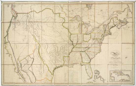
Première édition, sixième état (Ristow). Rare carte murale repré-
sentant la nouvelle nation d’une côte à l’autre. J. Melish est
l’éditeur de cartes américain le plus important de cette
deuxième décade. Ses cartes sont dressées d’après les cartes
militaires et officielles les plus récentes, il révise et corrige ses
cartes régulièrement et limite leur tirage à 100 exemplaires.
Au départ, Melish prévoyait de ne représenter que la partie à
l’est des Montagnes Rocheuses mais il décida de rajouter 2
feuilles afin de montrer l’ampleur du territoire des Etats-Unis
d’une côte à l’autre. Cette carte était si précise et exacte,
qu’elle fut utilisée lors de différent traités afin de définir les fron-
tières.
- “Map of the United States with contiguous British & Spanish
Possessions Compiled from the latest & best authorities by
John Melish”. Engraved by J. Vallance and [H.S.] Tanner. Nicely
enhanced by the figure of an American bald eagle carrying olive
branches, arrows and a striped shield.
FIRST EDITION in a sixth state (Ristow). The following new
place names are introduced in southern Indiana: Brookville,
Blackford, Brownstown, Busserow C., Centreville, Darlington,
Fredericksburg, Lawrenceburg, Loughery, Cr., Madison,
Orleans, Paoli, Princeton, Salem, Shaker T., Troy, Vernon, and
White Water R. In southern Indiana “Harmonist Society” is
changed to “Harmony” and “Clarksville” to “New Albany”. A
dotted line is added in eastern Indiana to enclose a land grant
west of Centreville. The name “Charleston” is added in northern
Kentucky.
The first state of the map (1816) is the unique proof copy depo-
sited in the Library of Congress for copyright purposes. Many
editions and states followed, as late as 1823, supposedly done
in no more than one hundred issues each.
First published in 1816, this great wall map was among the first
to show the new nation from coast to coast. An exquisite map,
it distinguished Melish as the leading American map publisher
of the second decade and placed American maps on equal
footing with those produced by the prestigious firms in London
and Paris. Incorporating data from state and military maps as
11
30