Version HTML de base


these became available Melish frequently revised and corrected
the plates, limiting each printing to 100 copies. (Schwartz and
Ehrenberg).
Melish originally planned to include only the portion of the
United States east of the Rocky Mountains, but decided to add
two sheets, in order to show “at a glance the whole extent of
the United States territory from sea to sea” (Melish,
Geographical Description, Philadelphia, 1816).
Martin and Ristow identify seven states of the 1816 edition.
Melish published new editions in 1818 (five states), 1819 (two
states), 1820 (eight states), 1822 (two states), and 1823 (one
state) for a total of twenty five different issues.
Born in Scotland, Melish settled in the United States in 1811.
He is credited with bringing American cartography up to world
standards. Walter Ristow couldn’t heap enough praise on to
this map. The map was considered so accurate that it was
used in several treaty negotiations to determine boundaries. -
W.W. Ristow, American maps and mapmakers, 1985.
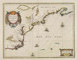
31 JANSSON, J. Nova Anglia Novum Belgium et Virginia.
Amsterdam, 1636 [1639-1649]. Beau col. d’époque.
Bel exemplaire. - In original colours. In good condition.
385 x 501 mm.
800 / 1 000
€
Carte basée sur la carte prototype de Johannes de Laet. J. de
Laet était directeur de la Compagnie des Indes Néerlandaises.
Texte en français. - In the 1636 edition of the “Appendix”,
Johannes Janssonius inserted this important and influential
map of the eastern seaboard from C. of Feare (Cape Look out)
to Nova Scotia, based on Johannes de Laet’s prototype map.
De Laet was a director of the Dutch West India Company, which
controlled the Dutch penetration of the Americas. It is one of the
earliest attempts on a Dutch map to show the Great Lakes in
any form. Janssonius shows an unnamed lake (probably Lake
Champlain), a “Lac de Yroquois” (Ontario?) and further west a
“Grand Lac”, which Tooley holds to be Lake Superior. First
state, with the heart shaped cartouche. With French text on
verso. - Burden, America 247. A first state.
32 JANSSON, J. Virginiae partis australis, et Floridae.
Amsterdam, 1639-1649. Col. d’époque. Fente restau-
rée en bas du pli central sur 11 cm. - Orig. col. Split in
lower part center fold (11 cm) expertly repaired. 384 x
505 mm.
750 / 850
€
Well known map of the Southeast extending from the southern
part of Virginia to northern Florida. This is the first state of
Jansson’s map which is virtually identical to Blaeu’s map of
1638. The map depicts the English and French colonial inte-
rests in the region as depicted by their respective Royal coat of
arms and several new colonies are noted. At the southern end
of the Appalachians is a note concerning gold and silver mines.
French text on verso. - Burden, North America, 254, state 1.
OCÉAN ATLANTIQUE - ANTILLES
33 JANSSON, J. Insulae Americanae in oceano septen-
trionali. Amsterdam, 1639-1644. Beau col. d’époque.
Pli central en partie fendu restauré. 3 infimes trous
bruns. - In original colours. Split in top part center fold
expertly repaired. 3 small brown holes. 379 x 522 mm.
500 / 700
€
Showing the Gulf of Mexico and the West Indian Islands, and
the adjacent North and South American coastlines. The map is
based on the map by Gerritsz., except for the addition of the
west coat of Central America. The nomenclature in North
America is virtually identical, other than the addition of Virginia
on this map.
34 SERVICE HYDROGRAPHIQUE DE LA MARINE. Iles
Vierges - Trinidad - Porto Rico - Guadeloupe -
Martinique - Antigua. Paris, ca. 1960. Lot de 14 cartes
de format in-plano et grand in-folio. Plis marqués,
rousseurs éparses, taches brunes, 1 carte coupée en 2
(îles Vierges).
200 / 300
€
Ensemble de cartes figurant différentes îles des Antilles : Trinité-
et-Tobago, Iles Vierges, Porto Rico, Antigua, la Martinique et la
Guadeloupe.
35 HONDIUS, H. / JANSSON, J. Mappa Aestivarum
Insularum, alias Barmudas. Amsterdam, 1639-1649.
Beau col. d’époque. Bel exemplaire. - In original
colours. Paper very slightly age-toned as usual, altoge-
ther good condition. 391 x 516 mm.
1 200 / 1 500
€
Reprend la carte de Blaeu de 1630 avec un cartouche simpli-
fié. Ornée des armes des Bermudes et d’Angleterre et d’une
liste des propriétaires et tribus que comprend l’île. Texte en
31
12