Description
'Mechelen' (vue panoramique de Nicolas Visscher, publiée dans' Theatrum praecipuarum urbium ducatus Brabantiae 'de Schut, 1656, 210 x 275 mm), – idem, coloré – 'Mechelen, Mechlinia, Machlinia' (anonyme, ch.1790–1800, couleur contemporaine, 165 x 285 mm), – 'Mechlinia, Malines' (de Johann Christian Leopold d'après un dessin de Friedrich Bernhard Werner, vers 1721–1750, 200 x 295 mm), – 'Vue de la ville de Malines' (épreuve optique, éditée par Hocquart, vers 1790, 190 x 250 mm), – 'Mechelen' (vue panoramique, édité par Frederik De Wit, vers 1750, 220 x 275 mm), – 'Malines, ville considérable des Païs bas catholiques' (vue panoramique, édité à Paris par Basset, coloriage contemporain, 190 x 255 mm (x2)), – 'Malignes' (par Alphonso Lasor, coloriage contemporain, vers 1713, 90 x 135 mm), – 'La ville de Malines en Brabant '(publié à Amsterdam, par Pieter Van der Aa, 335 x 410 mm), – 'Mechlin ou Malines la capitale de l'une des dix provinces des Pays–Bas '(carte de l'histoire de Rapin en Angleterre, 1746, 385 x 470 mm. Tot. : 12 ex.
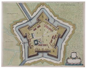
■ (MECHELEN) — An extensive collection of 17th and 18th century historical–topographical and cartographic prints about Mechelen and the surrounding area:
– 'Forti furor arma ministrat '(panoramic view by Daniel Meissner, c. 1625, 100 x 145 mm),
– 'Mechelen '(panoramic view by Nicolas Visscher, published in' Theatrum praecipuarum urbium ducatus Brabantiae 'by Schut, 1656, 210 x 275 mm),
– idem, coloured.
– 'Mechelen, Mechlinia, Machlinia '(anonymous, c. 1790–1800, contemporary colored, 165 x 285mm),
– 'Mechlinia, Mechelen '(by Johann Christian Leopold after a design by Friedrich Bernhard Werner, ca.1721–1750, 200 x 295mm),
– 'Vue de la ville de Malines' (optical print, published by Hocquart, ca.1790, 190 x 250mm),
– 'Mechelen '(panoramic view, published by Frederik De Wit, ca.1750, 220 x 275 mm),
– 'Malines, ville considérable des Païs bas catholiques' (panoramic view, published in Paris by Basset, contemporary coloring, 190 x 255 mm (x2)),
– 'Malignes' (by Alphonso Lasor, contemporary colouring, ca.1713, 90 x 135 mm),
– 'La ville de Malines en Brabant '(published in Amsterdam, by Pieter Van der Aa, 335 x 410 mm),
– 'Mechlin or Malines the capital of one of the ten Provinces of the Netherlands' (map from Rapin's History of England, 1746, 385 x 470 mm)
Tot. : 12 ex.
DESCRIPTION NL.
■ (MECHELEN) — Een omvangrijk geheel 17de en 18de–eeuwse historisch–topografische en cartografische prenten omtrent Mechelen en omgeving:
–'Forti furor arma ministrat' (panoramisch zicht door Daniel Meissner, ca. 1625, 100 x 145 mm),
– 'Mechelen' (panoramisch zicht door Nicolas Visscher, uitgegeven in 'Theatrum praecipuarum urbium ducatus Brabantiae' van Schut, 1656, 210 x 275 mm),
– idem, ingekleurd
–'Mechelen, Mechlinia, Machlinia' (anoniem, ca. 1790–1800, eigentijds gekleurd, 165 x 285mm),
– 'Mechlinia, Mechelen' (door Johann Christian Leopold naar ontwerp van Friedrich Bernhard Werner, ca. 1721–1750, 200 x 295mm),
– 'Vue de la ville de Malines' (opticaprent, uitgegeven door Hocquart, ca. 1790, 190 x 250mm),
– 'Mechelen' (panoramisch gezicht, uitgegeven door Frederik De Wit, ca. 1750, 220 x 275mm),
– 'Malines, ville considérable des Païs bas catholiques' (panoramisch gezicht, uitgegeven in Parijs bij Basset, eigentijds koloriet, 190 x 255 mm (x2)),
– 'Malignes' (door Alphonso Lasor, eigentijds koloriet, ca. 1713, 90 x 135 mm),
– 'La ville de Malines en Brabant' (uitgegeven te Amsterdam, door Pieter Van der Aa, 335 x 410 mm),
– 'Mechlin or Malines the capital of one of the ten Provinces of the Netherlands' (plattegrond uit Rapin's History of England, 1746, 385 x 470 mm)
Tot. : 12 ex.